skip to main |
skip to sidebar
As of January 2009, Section 3150 of the Public Sector Accounting Board (PSAB 3150) requires Canadian municipalities to report on their tangible capital assets including roads, bridges, utilities, water systems, sewer networks and land. The accuracy of such a report is based, in part, on the currency of a municipality’s infrastructure inventory databases. However, these databases are often out-of-date due to the as-built backlog.
The as-built backlog refers to the delay experienced between when infrastructure has been constructed and when information about this construction is entered into the records database. These delays often span months and sometimes years and make it difficult to provide reliable information about the infrastructure for field, management and regulatory requirements such as PSAB 3150.
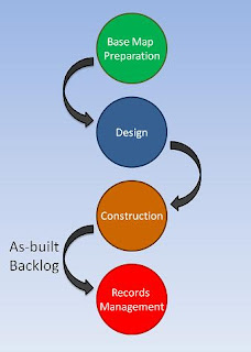 The as-built workflow can be explained with an example. A new subdivision project typically starts by assembling a collection of cadastral maps, existing infrastructure data and other information from a variety of sources to create a base map. Subdivision design is next; new infrastructure is drafted, existing infrastructure is updated and detailed design drawings for construction are created. Then construction takes place and upon completion, information about the construction is collected and compared to the design documents to create an as-built drawing. This as-built information is then used to update the infrastructure inventory database.
The as-built problem arises for several reasons:
- Accelerated development during booming economies often means that engineering and construction firms have all-hands-on-deck to keep up with construction demand. Consequently, creating as-built drawings is sometimes just not a priority.
- As-built drawings are often created from paper design documents that contain redline markups describing the as-constructed information. These paper documents are then re-drafted to create an electronic version that is added to the infrastructure inventory database. The re-drafting effort is error prone and time consuming.
- As-built drawings and the infrastructure inventory database are often maintained via different systems (typically CAD and GIS) and by different departments. Loading CAD data into a records database may require translation, editing for topology and other inefficient workflows.
As you can see, workflow contributes to the as-built backlog which impacts the currency of the infrastructure database and inadequate currency impacts the accuracy of PSAB 3150 reporting. If your infrastructure database is months or years out-of-date then how can you be sure that your PSAB 3150 reports on tangible capital assets are accurate?
The solution requires a new way of thinking. Stay tuned as I discuss proposed solutions to the as-built problem in future posts.
Until next time…
 If you thought 3D was hard, think again. Maybe a different point of view would help.
I recently had the pleasure of attending a seminar entitled “A New Dimension in GIS – 3D Analysis”, hosted by the British Columbia Chapter of URISA, in which a half-dozen speakers shared their 3D GIS experiences and insight during this one-day event. Convergence: The opening keynote presentation by Doug Eberhard (Senior Director, Autodesk) set the tone of this event by providing us with an eye-popping vision of the future in which the convergence of design, geospatial analysis, simulation and visualization are fuelling the emerging business of digital cities. According to Eberhard, at the heart of digital cities are models. These models range from model agencies and model designers to model contractors and model operators. These models allow us to examine our world in new ways –ways that can help us become a model planet.
New Perspectives: Dan Campbell (Manager, Graphics and Communications, City of Vancouver) discussed the City’s experiences, gathered over the last 20 years, in working with 3D models. In fact, it was Campbell that said, “3D is Easy; it’s 2D that’s hard.” His point was that we live in a 3D world and no-one needs to teach us how to interpret this 3D world. And yet, when we work with infrastructure designs, architectural plans and maps we force our 3D world into a 2D abstraction. According to Campbell, this 2D abstraction for the non-professional is equivalent to trying to read hieroglyphics - misinterpretation and lost meaning is often the result.
Integration: Dale Lutz (Vice President, Safe Software) explored the topic of integrating CAD, Building Information Modeling (BIM) and geospatial data and discussed the role of CityGML, Industry Foundation Classes (IFC) and LandXML in the creation of 3D models. Various integration scenarios were also presented including the use of 2D CAD buildings with LIDAR to create 3D extruded buildings and the use of 3D geo-referenced BIM. Key Takeaway: For me, one of the key takeaways of this seminar was that 3D GIS is about making it easier for the users of the information and not the CAD and GIS gurus. It’s about an easier way to analyze, visualize and communicate information about our 3D world. The boundaries between design, visualization and geospatial analysis are blurring. And yet, it’s the people and processes and not the technology that remain obstacles in realizing the vision of 3D digital cities. Data integration and an open, non-proprietary approach continue to be at the heart of the solution.Until next time...

 The as-built workflow can be explained with an example. A new subdivision project typically starts by assembling a collection of cadastral maps, existing infrastructure data and other information from a variety of sources to create a base map. Subdivision design is next; new infrastructure is drafted, existing infrastructure is updated and detailed design drawings for construction are created. Then construction takes place and upon completion, information about the construction is collected and compared to the design documents to create an as-built drawing. This as-built information is then used to update the infrastructure inventory database.


